Duluth Airshow & Aviation Expo – Duluth, MN

Duluth Airshow & Aviation Expo – Duluth, MN

The Duluth Airshow

Don’t miss this chance to witness their incredible skills firsthand at Minnesota’s largest airshow.

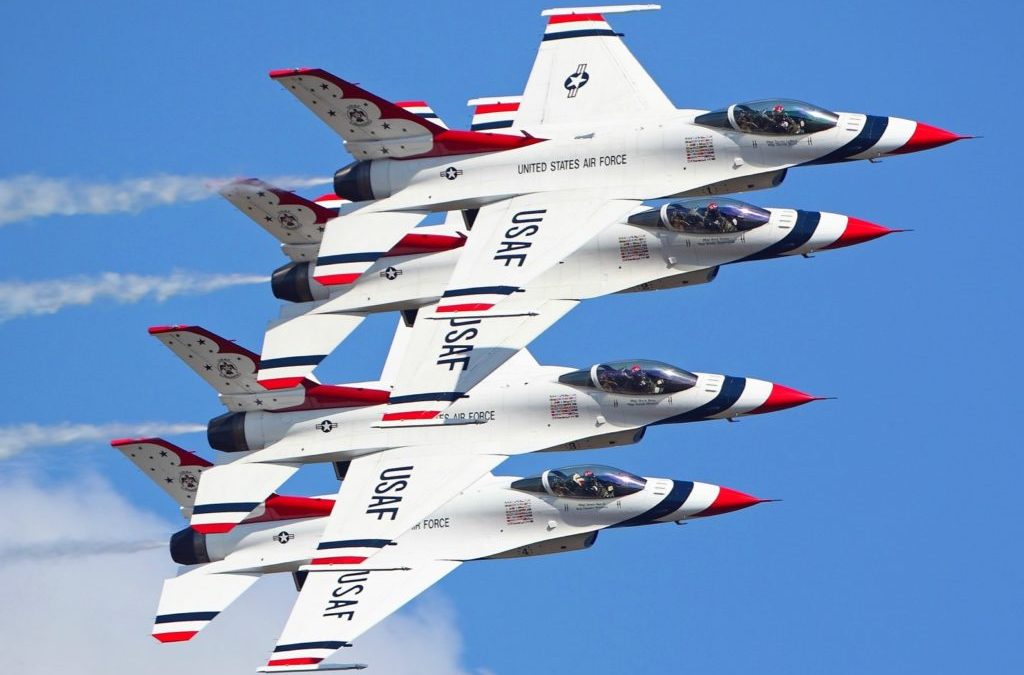
Minnesota’s largest airshow returns to the Duluth International Airport. The Duluth Airshow, presented by Essentia Health features the U.S. Air Force Thunderbirds and the U.S. Navy F-18 Rhino Demonstration! The Duluth Airshow will also feature Randy Ball and his MiG-17, Skip Stewart in a Pitts biplane, the P-35 Lightning presented by the Bong Veterans Historical Center, Britt Lincoln presented locally by Super One Foods and many more! In addition to the performances in the sky, don’t miss one of the most expansive displays of military aircraft in the Midwest!

F-16 Fighting Falcon > Air Force > Fact Sheet Display

The Thunderbirds aren’t just pilots – they’re aerial rockstars, showing off the Air Force’s top-notch F-16 Fighting Falcon. Flying individual machines, as a team, they create spectacularly synchronized stunts that will leave you breathless. From gravity-defying twists to thrilling side-by-side maneuvers, the Thunderbirds will leave you breathless with their perfect blend of grace and power.

Event

The Duluth Airshow & Aviation Expo

Saturday, May 18th & Sunday, May 19th

Premium, upgraded and general admission tickets here!

Location

Duluth International Airport

Minnesota Scientific & Natural Areas 7 hour Road Trip

Minnesota Scientific & Natural Areas 7 hour Road Trip

White pine trunks in the old-growth forest at Lost 40 SNA.

ow about a road trip?

 
Minnesota Scientific & Natural Areas: Get lost in the beauty of MinnesotaSNAs with this route – literally! There are four SNAs with the word “lost” in their names, and this seven-hour route connects them all. The route starts up north with Lost Lake Peatland SNA and Lost River Peatland SNA. After that, take a short drive south to the old growth pines at Lost 40 SNA and round the trip out at Lost Valley Prairie SNA in southeast Minnesota. A word of caution though, peatlands are largely inaccessible by road, and extremely challenging to traverse on foot. Prepare wisely, as this route is a challenging adventure!

Scientific and Natural Areas are public lands open to recreational activities that do not disturb natural conditions, such as birdwatching, nature photography, and hiking. SNAs are established for their outstanding ecological features, which we want people to enjoy. You may see management activities such as prescribed burns and control of invasive species. Research equipment is also sometimes seen on sites.

A teardrop island in the Red Lake Peatland SNA

Please read and follow these visiting guidelines as well as the specific recreational opportunities provided at individual SNAs (things you can do and rules). Working together, we can keep these unique places healthy and available for everyone to visit and enjoy.

Duluth Homegrown Music Festival – Duluth, MN

Duluth Homegrown Music Festival – Duluth, MN

The Minnesota Zoo: Annual Farm Babies Event! – Apple Valley, MN 

The Minnesota Zoo: Annual Farm Babies Event! – Apple Valley, MN 

The Minnesota Zoo’s annual Farm Babies event is one of the zoo’s largest—and cutest—events.

Throughout the event, calves, goat kids, lambs, bunnies, chicks, and piglets will be on display at the Wells Fargo Family Farm. This beloved event provides guests with unique, up-close experiences that provide great photo opportunities plus on weekends include music, games, tractors, and more to enjoy. Farm Babies is included with regular zoo admission. Enjoy the warmer weather as you stroll along the Northern Trail to view tigers, gazelles, moose or brown bears at the Russia Grizzly Coast, Tropics Trail, Northern Trail, Discovery Bay aquarium and new Tree Top Trail plus more all included with zoo admission.

Enjoy special activities every Friday – Sunday at the Wells Fargo Family Farm in celebration of Farm Babies.

10 am & 1 pm – Photo op with Clydesdale horse
10 am, noon, & 2 pm – Live music
11 am – Goat & sheep demonstration
11:30 am & 3 pm – Milking demonstration
2:30 pm – Pig & chicken feeding by Farm staff
10:30, 11:30, 12:30, 1:30 and 2:30 (Saturdays only) – Dakota County Library Story Trail

 Celebrate the season with animals, farm demonstrations, and more.

Event

Farm Babies

Friday, April 26th thru Sunday, May 19th

Location

The Minnesota Zoo

13000 Zoo Blvd, Apple Valley, MN 

doitinnorth shop/share gallery

Lambs & Ivy Baby Farm Plush Barn with 4 Stuffed Animals Toy 

ICYMI

Walker Art Center: “Keith Haring: Art Is for Everybody”

18 Spring Waterfalls To Explore In Cook County, MN

18 Spring Waterfalls To Explore In Cook County, MN

Brule River

Waterfall Season In Cook County

Visit Cook County: After the snow melts, experience the raw power of North Shore waterfall season – a fleeting yet unforgettable spring wonder. Hundreds of thousands of acres of melted snowfall finds its way into Lake Superior and on the way, creates quite the show. The roaring rage of waterfalls in Minnesota is certainly a sight to be seen, heard and felt.While they are at their peak in the spring season, waterfalls can be enjoyed all year long. In the winter time, the waterfalls freeze and create scenic ice sculptures. In the summer, the rivers are warm enough to take a hike through. Using caution, you can find hidden falls that can’t be seen by a hiking trail. In the fall, the blue rush of water is the perfect contrast to the fall colors.From the smaller, pop-up falls all along Highway 61 to the North Shore’s most dramatic drops, Cook County has the most diverse range of waterfalls in Minnesota. Some of the more dramatic include Devil’s Kettle Falls in Judge C.R. Magney State Park, the ephemeral “phantom falls” that pour from the cliffs lining Highway 61, and the High Falls of the Pigeon River in Grand Portage State Park. At 120 feet, High Falls is the highest waterfall in Minnesota, and also serves as the border to Canada. No wonder it is sometimes called “Minnesota’s Niagara.” Viewing this waterfall is a bucket list item to cross off.Other local favorites include Cascade River State Park in Lutsen, Cross River in Schroeder, and the Kadunce River just north of Grand Marais.

Download the Cook County Waterfall Map Guide

North Shore Scenic Drive

221 West First Street

In a league of its own, the 154-mile North Shore Scenic Drive is Minnesota’s only designated “All-American Road.” The route parallels the inland coast of the world’s largest freshwater lake, Lake Superior, bisecting ancient rock formations and thousands of acres of forests rising…

Brule River

4051 Highway 61

Eight miles up the road from Grand Marais, at Judge C.R. Magney State Park you’ll meet the Brule River. Best known for the Devil’s Kettle waterfall where the river splits and half the river enters a cauldron, the Devil’s Kettle, and disappears to places unknown…. Enter Judge…

Caribou River

7232 Highway 61

A short gradual climb along the river will bring you to the spur trail of the Superior Hiking Trail to the base of the waterfall. Park at Caribou State Wayside rest; off of Highway 61

Cascade River

3650 W. Highway 61

A breathtaking series of large cascading waterfalls; this location includes parking and a walking path, which makes hiking along multiple waterfalls possible. The Cascade River flows from one ledge after another for a total drop of 900 feet during the last three miles to Lake…

Cross River

Highway 61

Best falls seen right from the highway at the wayside rest in Schroeder. Just eight miles north of the county line, you will find easy access and parking. Bring a raincoat. The view from the bridge on scenic Highway 61 is one of the best, and the spray might ruin your hair.

Devil Track River

Highway 61

The Devil Track River is located 3.5 miles northeast of Grand Marais on Highway 61. Follow the Superior Hiking Trail on County Rd. 58 (Lindscog Rd.) for a view of the Devil Track River Gorge. In the winter, the falls are more easily accessible by snowshoe with caution.

Fall River

Highway 61

This waterfall can be found just two miles west of Grand Marais along Highway 61. The main waterfall is on the lakeshore side of Highway 61 and plunges into Lake Superior. Follow the Gitchi-Gami State Trail to the bridge that offers incredible views of the falls.

Flute Reed River

5059 Highway 61

The Flute Reed River empties into Lake Superior at Hovland, 18 miles northeast of Grand Marais, MN. It is designated a trout stream by the state. The river is 9.2 miles long, with an unnamed waterfall on the lakeside of Highway 61.

Granite River

Saganaga Lake

The Granite River is a favorite route for many people who visit the Gunflint Trail. The river flows north from Gunflint Lake along the border of Minnesota and Canada up to Saganaga Lake. The river is approximately 25 miles long with around 13 portages around rapids and small…

Kadunce River

Highway 61

Just 12.7 miles east of Grand Marais, the Kadunce has easy access, up-top viewing, with a hike on the Superior Hiking Trail. Feeling adventurous? Hike up the shallow river for a different vantage point. Parking is available in the lot off of Highway 61.

Onion River

6355 W Highway 61

Newly reconstructed trail from Highway 61 will bring you along the river for a canyon view. Legend has it that the river was created when Paul Bunyan shed tears while cutting the wild onions that grew in the woods nearby. Park at the Ray Berglund Memorial Wayside rest right off…

Pigeon River

9393 Highway 61

In Grand Portage State Park at 120’ the High Falls is the tallest waterfall in the state of Minnesota. Handicap accessible trail is about 1 mile long. During peak waterfall season, find a nearly permanent rainbow at the base of the High Falls. Parking is available in the Grand…

Poplar River

Ski Hill Road

Hike inland to roaring fall, cascades and canyons. You’ll find multiple waterfalls and rapids that are easily accessible from multiple locations. Upper Falls above Lutsen Mountains Ski Hill – park at the end of Ski Hill Road at the start of the connector trail for the…

BWCA watefall

Duncan & Rose Lake

Between Duncan and Rose Lake in the Central Gunflint Trail region. Must use a canoe to reach this area.

Pin It on Pinterest